

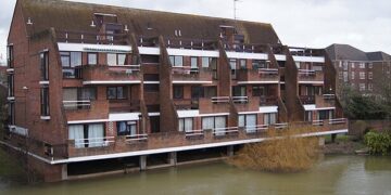


ANY HOMES built at Hall Farm will be on “low risk” flood land as opposed to “high risk” land, the borough council’s planning executive announced.
Cllr Wayne Smith, executive member for planning and enforcement at the borough council, said: “It’s well known that part of this site is prone to flooding, but we considered this from the outset and are not proposing any homes in the higher risk areas.
“Where part of a site lies in a higher risk area, this allows us to plan housing around it on the lower risk areas only – as we have done in several instances, including at Hall Farm.”
He was responding to concerns from the Wokingham Liberal Democrats over about the impact of flooding on borough housebuilding in the local plan update.
Cllr Stephen Conway, deputy leader of the group said that there are constraints on the borough, due to the waterways that run through it.
“If you add the impact of new development to the climate change risks, we have a flooding catastrophe,” he said. “There has been flooding in many of the sites considered in the local plan update.”
He believes that any building at Hall Farm will have an impact on the River Loddon downstream, in the borough’s northern parishes of Wargrave and Remenham.
“If it’s over-full, experts have said that it won’t go into the Thames, but just burst its banks,” he said. “Northern areas in the borough will be more susceptible to flooding as a result of Hall Farm.”
But Cllr Smith disputes this, and said that it is “not true” that development would increase the flood risk further downstream.
He said: “Developers would be required to include a range of sustainable drainage measures as part of their planning permission – again, as is normal practice.
“These would ensure that run-off from rainfall is drained at a rate that doesn’t overwhelm rivers and waterways.”
The councillor added: “We know this is an emotive issue but are confident that any proposed development at Hall Farm would pose no added flood risk, either to residents living on site or those further downstream.”

Phiala Mehring, vice chair of the National Flood Forum and chair of the Loddon Valley Residents Association is well versed in the flood risks associated with the River Loddon.
She said that there are both immediate and long-term threats of flooding to residents, due to the combination of surface and fluvial, also known as river, flooding.
“Surface water flooding is man-made and is a result of having too many impermeable surfaces,” she said. “When next to a river, you can get flooding in both directions.
“Rain water can’t get into the river, and the river could burst it’s banks.”
Ms Mehring said that there are ways to “plan our way out of flooding” but that traditional housing developments would increase flooding in the Hall Farm area.
“If built with traditional hard surfacing, yes, it will increase flooding,” she said.
Cllr Rachel Burgess, Wokingham Labour leader, said that a recent planning guide encourages local authorities should avoid building in areas of flood risk.
“Make no mistake — building houses on flood risk zones increases the likelihood those houses will flood,” she said.
“Yet in Wokingham’s local plan 41 sites intersect Flood Zone 2 by more than 20%, and the Hall Farm site’s proximity to the River Loddon is a serious concern for residents.”
Cllr Burgess said that the River Loddon puts “serious constraints” on the Hall Farm site.
“The council’s own documents note we should proceed with caution,” she said. “While the local Conservatives decide between them whether they support Hall Farm or not, we cannot simply press ahead with these developments without serious consideration of the risk to residents.”
Flooding mitigation
Ms Mehring said that technology used to slow a river can fail if not maintained properly.
“The second you start to dabble with rivers, you get effects that you haven’t’ planned for,” she added.
Ms Mehring said it would be interesting to see if permeable driveways and rain gardens would be included in the plans.
She also suggested that the land could be used for flood storage instead. This is when the land is specifically used to hold onto water, and could be in the form of wet woodlands or water meadows.
These, she said, can help to slow the flow of the river.
“Could the land be used instead to help us adapt to climate change,” she questioned. “If there was a golden rule for planning, it would be, don’t build in or around the flood plain.”
Flood zones at Hall Farm
Latest flood maps put a large portion of the site in Flood Zones 3 and 2.
Flood Zone 3 has a one in 100 or greater annual probability of river flooding. Flood Zone 2 has between a one in 100 and one in 1,000 annual probability of river flooding. And Flood Zone 3 is land that has less than one in 1,000 annual probability of flooding.
The Flood Zones shown on the Environment Agency’s Flood Map for Planning do not take account of the possible impacts of climate change and future probability of flooding.
Ms Mehring said this is very important.
“We are seeing more of what we would have called rare flood events,” she said.
Cllr Conway was also concerned that the boundaries of flood risk will expand as the climate crisis continues.
“How much of this is being factored into the plans,” he questioned. “The council should seek out advice on projected and modelled future flood risk. Things are changing rapidly.”
He added: “If you’ve been affected by flooding, you know how devastating it is.”
Cllr Smith said that specialist flood risk assessment were commissioned ahead of considering any sites for the local plan update.
These are available to view on the council’s website.
He explained that decisions were also made using the Environment Agency’s flood zone map.
“This is standard practice for local authorities when preparing their development plans,” he said.
Cllr Smith added that the areas known to flood are proposed to be an “eco valley”.
This would be an open green space with landscaping to further reduce the flood risk, he said, and would also have measures to conserve and enhance the area’s biodiversity.
“This will open up a significant amount of land for public enjoyment which was previously inaccessible,” he said.
Ms Mehring said it would help to look at the flood risk from a river catchment perspective.
The River Loddon begins around 15 miles away, in Basingstoke.
“Basingstoke has plans to build along the Loddon,” she said. “The planning process doesn’t look at it cumulatively. If planning was catchment based, that would be better.”
Ms Mehring urged Wokingham Borough Council to scrutinise any plans for the site closely.
“It needs to be made future-proof,” she added. “The council should be talking to and listening to flood groups.”
National view
Cllr Burgess said that on a national level, the government is not doing enough to ensure communities are protected from flooding.
“A key part of this prevention is to ensure that inappropriate building in flood zones must stop,” she added. “Yet instead Conservative policy, that favours developers over ordinary people, forces unreasonable house building targets on areas like Wokingham, which in turn causes the inevitable consideration of development sites with associated flood risks.”
Cllr Burgess said that residents should not hold their breath for a change in national policy.
“The climate emergency means we have to do things differently – and that means halting development on high risk flood zones,” she said.
“With the climate emergency ensuring that extreme weather is becoming more commonplace, there is no doubt that building in flood risk areas such as Hall Farm increases the risk of flooding for our residents.”


