


THE Met Office is warning that winter weather could return to Wokingham by the end of the week – and if it does, it will have a sting in its tale as it will bring a “risk of easterly wind and significant snow”.
On Friday, the weather forecasters shared a weather warning that events at the North Pole is expected to lead to a prolonged cold snap across the UK. This, it warns, will lead to the cold weather conditions.
The warning notes that there is still uncertainty about what the Arctic blast will mean, it does think there is “an increased risk of cold conditions in the latter part of February, including the possibility of heavy snowfall”.
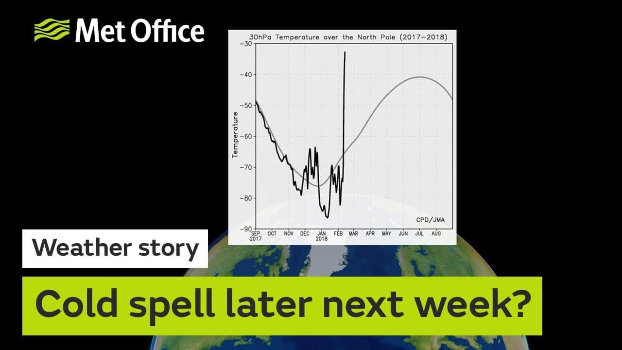
To help explain its thoughts, it has released a video explaining what has happened at the North Pole and how it affects weather in the UK.
It is known as Sudden Stratospheric Warming and is a dramatic rise in air temperature around 30km above the North Pole.
Prof Adam Scaife, of the Met Office Hadley Centre, said: “This warming results from a breakdown of the usual high-altitude westerly winds and it often leads to a switch in our weather: with cold easterly conditions more likely to dominate subsequent UK weather.”
Frank Saunders, a Met Office Chief Operational Meteorologist, added: “A Sudden Stratospheric Warming implies around a 70% chance of cold conditions across the UK. There tends to be a lag of about 10 days before we see the downstream effects on the UK’s weather.”
Snow is difficult to forecast with accuracy. It needs a range of conditions including the right amount of moisture in the air. However, advance models suggest that the cold snap will arrive and bring with it disruption.
One amateur forecaster, @StormchaserUKEU, said they were getting “more and more confident” that “The U.K. could see some of its coldest conditions for many years”.
I’m getting more and more confident. NW #Europe is in for some pretty extreme weather in terms of #cold and #snow. The U.K. could see some of its coldest conditions for many years with model outputs not backing down still some upgrades appearing. #StayTuned pic.twitter.com/DoycXa3peG
— WEATHER/ METEO WORLD (@StormchaserUKEU) February 18, 2018
The tweeter also shared a speeded up graphic showing how temperatures across Europe will plunge as a result of the cold snap, with the UK bearing the brunt – and the south, including Wokingham, particularly hit.
WOWZERS most severe spell of cold weather this winter could be on the way for next week. Follow for updates on this freezing and #snowy spell… #uksnow #Europe #extremecold pic.twitter.com/gIjDRaavfx
— WEATHER/ METEO WORLD (@StormchaserUKEU) February 16, 2018
And BBC Wales’ weatherman Derek ‘The Weather’ Brockway, shared charts that suggest temperatures, with windchill, could feel like -16ºC.
Blimey! If these charts from @ECMWF are right February may end on a very cold note with bitterly cold east winds. Threat of significant snow too. Not definite yet but I wouldn't rule it out!
Stay tuned for updates @bbcweather #uksnow pic.twitter.com/sVSKs0iCDV— Derek Brockway – weatherman (@DerekTheWeather) February 18, 2018
Not all forecasters are convinced the weather will turn cold.
Twitter user @weathertrending warned that some forecasters’ models are NOT showing the cold weather coming.
“It’s a possibility, but model skill at that range is limited. A week is a very long time,” they warned.
HYPE ALERT! Whilst some are choosing to show model signals of intense cold and disruptive snow arriving in the UK by next weekend, other models do not show this signal. It's a possibility, but model skill at that range is limited. A week is a very long time. #balance #uksnow #SSW pic.twitter.com/mv836lR0yi
— weathertrending (@weathertrending) February 18, 2018
The models that do forecast snow do show that Wokingham will be in the area affected. We will keep monitoring the forecasts.


